A spray of rust-colored soil lands with a thud in the forest surrounding Juneau’s John Muir trail, disturbing the devil’s club for a moment. Over his shoulder, UAF soil scientist Diogo Noses Spinola is deftly swinging a shovelful of dirt downhill of us. He takes a break to let Raquel Portes, his partner and fellow soil scientist, break up the rocks and roots, before loading his shovel and beginning again. On the other side of a meter-wide pit, Jennifer Fedenko, a master’s student at Oregon State University, and Ben Pierce, an undergraduate student from the University of Wisconsin-River Falls, mirror their actions.
The four are working with CRMRN steering committee member Dave D’Amore. They’ve traveled from Brazil, Wisconsin, and Oregon to study soil formation in the temperate rainforest surrounding the US Forest Service Juneau Forestry Sciences Lab.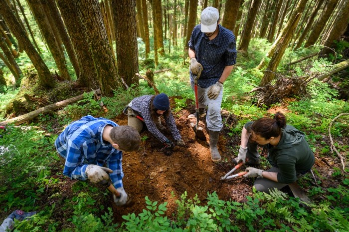 In the hour or so we’ve been standing on this section of steep, shaded forest floor, the team has excavated about half a cubic meter of the iron-rich, clay-heavy soil beneath our feet. They stop from time to time to speculate on what they are uncovering; a piece of charcoal buried in the clay or a slab of shale, layered like sheets of paper in a notebook, that breaks apart in your hands to reveal the delicate roots of a fungi growing between sections. They commence digging again with the practiced synchronicity that comes with a summer spent swinging shovels together in close proximity.
Another hour of sweat and dirt later, the metal clang of shovels on solid rock rings out about a meter down. Then the real work begins.
“This is the nicest soil profile we’ve dug all summer,” Spinola comments with a note of pride. Often, large roots or rocks get in the way of creating a level cut, but the face of this profile is relatively even and clean. It’s the sixteenth pit Spinola has dug this season, with a rotating cast of help from other researchers and volunteers. 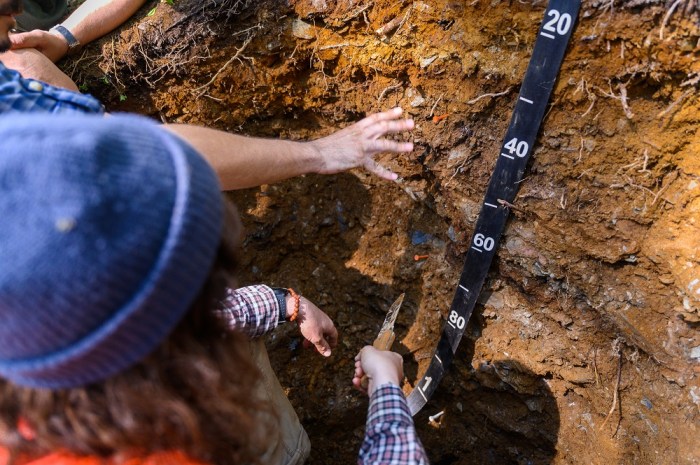 Passing tools between themselves, the four begin to describe their latest pit. We debate the best places to distinguish between soil horizons, which are the distinct layers that mark the different types of soil. A dark, rich layer made up of decomposed organic material lies at the top, followed by the bleached grey of weathered material known as the E horizon and a thick rust-colored layer that makes up the subsoil.
Each team member takes on a task. Fedenko begins identifying the soil’s hues and textures, how rocky or root-filled each layer is, and how fine or coarse the grains are. Portes and Pierce talk while collecting ziplock bags of each layer to measure the density. Spinola sketches a diagram of the soil in his field notebook. Together, they paint a scientific portrait of a soil thousands of years in the making.
The ultimate goal is to determine how the underlying rock beneath a soil, known as bedrock, affects the type of soil that forms and how much carbon is stored in it. Fedenko will be comparing the characteristics of the soil they describe with the underlying geology of the region. 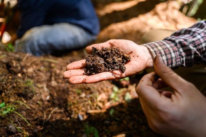 Southeast Alaska has a distinct geologic makeup, where belts of different bedrock types lie parallel to one another. The site I join them at is in a band of rock known as Gravina sedimentary, but less than four miles away, on the ridge across Mendenhall Valley, the bedrock is Gravina volcanic. At each area of distinct bedrock, the team picks sites that are as similar as possible in every other respect to one another– slope, slope facing direction, vegetation, elevation. Keeping other environmental factors constant allows them to compare how bedrock type influences what sort of soil forms there.
Spinola hammers a rectangular plastic tube into the face of the profile, removes a section of soil, and covers each end with duct tape to transport it back to the lab. When I watch quizzically, he stops to explain.
“One way to think about it,” says Spinola, “is like a finding clock that has been thrown in a blender. When you study that in the lab, you can find out what materials the clock is made of, how old they are, where they come from. But you can’t see how the clock fits together. Taking thin sections of the soil allows us to see the structure of the profile; how the roots fit, the orientation of rocks, and more. This tells us a lot more about how the soil functions than the mixed up samples we collect to look at.”
Later, when the samples and tools are safely stowed in packs, Spinola probes at the pit once more, speculating at the source of a pocket of dark, charcoal-like material before we turn away and bushwack back to the trail.


